Vietnam builds maps to warn of natural calamilties
Vietnam is among the five countries most affected by high rates of natural calamity in the world. It has experienced great loss of human life and property damage, according to the Asian fund for the prevention and fight against natural calamity.
 |
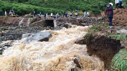
| A landslide caused by flash flooding in the northern province of Tuyen Quang (Photo:baotuyenquang.com.vn) |
To address the problem, the Ministry of Natural Resources and Environment has directed related agencies to build a system of maps warning of natural calamity and to issue these maps to areas of provinces and cities that are commonly affected by floods, whirlwinds, landslides and dangerous cold snaps.
Based on these maps with a scale of 1/50,000, natural calamity preparedness offices of these districts have implemented works at relevant communes.
Along with this official map system, another map system has been implemented by local people, according to the website of the Centre for Preventing and Reducing Natural Calamity.
“Locals draw on local maps dangerous areas that could be affected by flash floods or ways to escape a severe storm,” said the centre’s director Nguyen Huu Phuc.
Prominent among the affected provinces is the northern province of Nam Dinh, based on maps drawn by the community to deal with natural calamities.
Currently, USAID has supported Nam Dinh’s 24 communes to build the maps while setting up community-based groups to deal with natural calamities. The project has also supplied rescue equipment for times of calamity and guides local people to strengthen their houses for safety and to think ahead of how to deal with natural calamities that could occur.
Nguyen Quoc Thanh of the Geology Institute, who is in charge of creating the maps warning of potential natural calamities, said the maps helped inhabitants and local authorities know about and prevent losses caused by natural calamities.
It is expected that the detailed maps will be finished by 2020, he said.
Meanwhile, departments of natural calamity prevention in the central and southern regions have delivered maps and trained locals on how to deal with floods due to sea level rises in the provinces of Ninh Thuan, Khanh Hoa, Binh Thuan, Phu Yen, Dong Thap and Tien Giang.
The Minister of Natural Resources and Environment Tran Hong Ha says, "The maps have helped to define dangerous areas and areas that are being threatened with landslides that could affect inhabitants, transport and local economic development. The data in the maps are very important to serve works on the prevention, and reduction of losses caused by landslides during floods and storms in Vietnam’s mountainous areas.
(Source: VNA)
.
 về đầu trang


