Tropical depression weakens to low pressure area
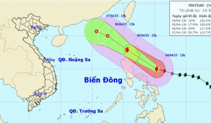
Tropical storm Maysak weakened again from a tropical depression to a low pressure area, said the National Centre for Hydro-Meteorological Forecasting (NCHMF).
 |
| The low pressure area will continue moving west-northwest, weaken then fade. (Credit: NCHMF) |
At 1pm on April 6, the low pressure’s centre was spotted at 20.4 degrees north latitude and 117.0 degrees east longitude in the northeast of the East Sea. The maximum winds in the centre reduced to below 39km per hour.
The low pressure area will continue moving west-northwest, weaken then fade.
Meanwhile, a cold spell is moving from the north of the country, possibly causing gale force winds and hail in mountainous areas, NCHMF added.
The cold spell is forecast to affect provinces in the northeast on the evening of April 7, then the east west and the northern central regions and several areas in the central region. It is likely to cause showers and scattered thunderstorms in the north and the central north region while mountainous regions in the north and the central north may see gale force winds and hail said the centre.
(Source: nhandan.org.vn)
 về đầu trang


