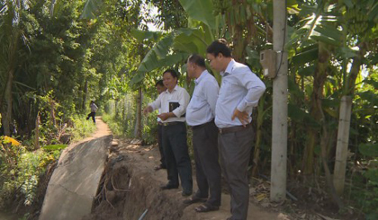
Surveying the landslide situation in Cai Lay district
On July 4, the delegation of Tien Giang Department of Agriculture and Rural Development surveyed the landslide situation in Cai Lay district to discuss measures to overcome.
The delegation investigated the actual site at three points of severe landslide along the banks of the Tra Tan river in Long Trung commmune and two severe landslides along the Moc Thuoc channel in My Thanh Nam commune, Cai Lay district.
 |
| At the site of severe erosion along Tra Tan River. Photo: thtg.vn |
These are the new landslides in the first 6 months of 2017, but the speed is faster and the level is getting worse, in which 3 landslide completely disappeared so eople have to open a temporary road inside the dike. The remaining points of the embankment fall into the river. Most of the landslides are major roads so people are meeting difficulty on traveling and transporting goods, at the same time, there is a risk that tidal water levels will overflow through these sites, garden.
From the beginning of 2017 to now, there are 25 new landslides in Cai Lay district, raising the total landslide point to the present time to 40 points with a total length of about 1,200 meters.
Before the erosion of the dyke in Cai Lay district, Tien Giang Department of Agriculture and Rural Development asked local authorities to quickly open temporary roads for people to safely circulattion, at the same time to reinforce face dyke to prevent tides. In addition, the function of district should conduct surveys, make estimates and projects, quickly deploy the work of overcoming landslides, especially strengthening the propaganda and mobilizing people to raise the spirit of vigilance to actively protect their life and property.
(According to thtg.vn-Translated by Nguyen Huu)
 về đầu trang


